Acropolis Case Study
Multitemporal SAR interferometry (MTInSAR) is utilized for long deformation time series analysis, using large stacks of SAR images acquired over the same area.
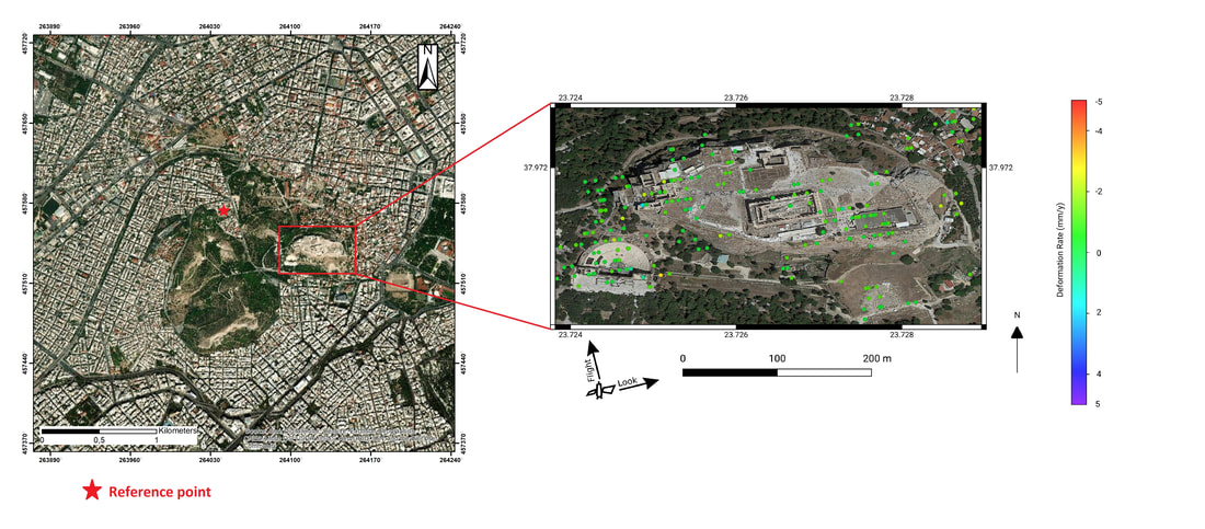
The MTInSAR technique that has been applied for the purposes of SCIENCE project is Persistent Scatterer Interferometry (PSI), as there was an abundance of persistent scatterers in the area of Acropolis of Athens in Greece.
PSI exploits permanently coherent scatterers, like buildings and metal structures, providing an estimation of the location and velocity of each scatterer along the line of sight (LOS) linked to the satellite acquisition geometry. In particular,a variety of such measurements are combined in the framework of the Acropolis of Athens case study aiming to produce highly accurate deformation maps for the prediction of the vulnerability of the ancient monuments (Parthenon, Erechtheion e.t.c) to ground deformation in time and space.
In the framework of the case study of Acropolis of Athens of the SCIENCE project,the dataset that has been utilized is consisted by 274 Single Look Complex (SLC) images acquired by the Copernicus Sentinel-1 satellites in ascending orbit (Relative Orbit 102). The selected Sentinel-1 SLC images cover the time period from October 2014 to May 2020.